

PLANS have been put forward to build a huge 2,500-home garden community around Farleigh Wallop in Basingstoke.
However, this project has been met with fierce opposition from residents who have formed an action group, calling on Basingstoke and Deane Borough Council to stop this proposal from going ahead.
Here is everything you need to know about the project, its impact, and the opposition.
What is the project?
Named ‘Upper Swallick Garden Community’, the project is planned by Viscount Lymington and the Trustees of the Portsmouth Settled Estates.

Where is it planned?
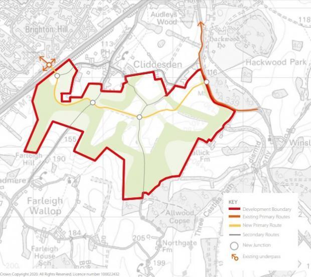
The 302.77-ha site is an extensive, undulating tract of arable farmland stretching east from the M3 on the southern side of Basingstoke, and immediately south of Cliddesden village. The site comprises a number of agricultural fields divided by hedgerows, small tracks and lanes. The site falls into three Parishes: the majority of the site falling within Cliddesden CP, a large portion within Fairleigh Wallop CP and a small area within Winslade CP. Cliddesden Primary School is situated in the centre of the site, with Otters Nursery School on situated on Farleigh Road to the west of the school.
The site promoter has suggested that the site would have direct access from the A339 in the east, junctions with Northgate Lane and Farleigh Road, and connect to Woods Lane at the M3 underpass.
Who owns the land?
Oliver Lymington is the current custodian of Portsmouth Estates.
What is the project offering?
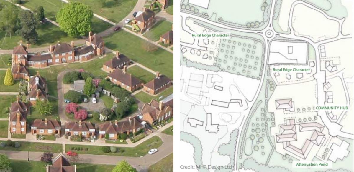
A message from the proposal read: "It proposes up to 2,500 homes, retail and employment and associated infrastructure.
"This garden community differs from conventional developments in that the proposal is on land under the sole ownership of the Estate, and therefore gives freedom and choice as to the type of development proposed that is not always available elsewhere."
Who is against the project?
Stand up for the North Hampshire Downs (STaNHD) is an action group set up by local people to protect the rural environment of the North Hampshire Downs, South of Basingstoke. Its petition, listed on Change.org, has so far been signed by 5,200 people.
What does the petition say?

The petition reads: "The North Hampshire Downs need to be protected for the benefit of all the Basingstoke and surrounding communities. The speculative concept of Upper Swallick Garden Village is inappropriate on this beautiful Downland.
“It would cover an area the size of central Basingstoke, consisting of at least 2,500 houses in stunning countryside south of Basingstoke. It would engulf the village of Cliddesden and have a devastating effect on Ellisfield, Winslade and all the surrounding villages as well as ruining easy access to the countryside from Brighton Hill and Hatch Warren.
“The rolling hills of the North Hampshire Downs are appreciated and loved by all who enjoy walking, running and cycling along the lanes and footpaths that cover this beautiful landscape. This area is the ‘Lungs’ of Basingstoke. The long views, fresh air and contact with nature and the seasons are important to our mental and physical wellbeing.
"Traffic levels would rise to unacceptable levels on the A339, B3046 to the Candovers and roads through Brighton Hill and Hatch Warren accessing Basingstoke. Rat runs would be created on smaller roads leading to Junctions 5, 6 and 7 of the M3.
“The land is farmed and should remain as farmland, it plays an important role providing food, flood protection and carbon capture, helping to prevent climate change, sustain the environment and supporting great biodiversity.
"Once this farmland is gone, it is gone."
Are there any council policy restrictions?
According to Basingstoke and Deane council, “the site is outside any defined settlement policy boundary, in a countryside location where new housing is generally only permitted as an exception, in line with current adopted Local Plan Policy SS6 (New Housing in the Countryside).
“The general principle of development in this location is therefore not supported by the council’s current planning framework. A large part of the site is located within the designated Cliddesden Neighbourhood Area. The Cliddesden Neighbourhood Plan is in the process of being prepared, however, as it is at an early stage it is not currently possible to clarify how it may impact on any future potential development of this site.
“Development of such a large-scale site in this location would not comply with the spatial strategy contained within the current adopted Local Plan 2011 – 2029, as Policy SS5 only requires the provision of 10 units within Cliddesden parish.
“Therefore, any potential for the site to be developed would need to be considered through the process of preparing the Local Plan Update, which will consider the potential for the allocation of land for new development.”
What are the potential impacts estimated by the council?
Basingstoke and Deane council has found that there would be potential archaeological implications associated with the proposed development of the site, and this is likely to require further investigation.
“The site is adjacent to the Cliddesden Conservation Area. There are a number of Grade II* Listed Buildings within Cliddesden village including Manor Farm House, Cliddesden Down House and St Leonard’s Church which are situated relatively close to the site boundary.
“There are also a number of notable buildings within Cliddesden village, a cluster of three notable buildings immediately to the east of the site at Swallick Farm, and to the south of the site at Broadmere, the Grade II listed Church of St Andrew’ is located. Further to the south are the Listed Buildings of ‘Farleigh Wallop House’ (Grade II*) and ‘Hassacks House’ (Grade II). Furthermore, Listed Park and Garden ‘Hackwood Park’ is located adjacent to the site at the north eastern boundary, joining at Swallick Wood.
“Development of the site therefore has the potential to impact upon the significance of a variety of heritage assets. There is also potential for ecological impacts due to the presence of Ancient Woodland at Middle Copse in the most western portion of the site, Swallick Wood adjacent to north eastern boundary, Kingsmore, Allwood and Fryingdown Copses and Doper’s Copse adjacent to southern boundary. The following are also designated as Sites of Importance for Nature Conservation (SINC): Middle copse, St Andrew’s church Wood & Drove, and Kingsmore, Allwood and Fryingdown Copses.”


Comments: Our rules
We want our comments to be a lively and valuable part of our community - a place where readers can debate and engage with the most important local issues. The ability to comment on our stories is a privilege, not a right, however, and that privilege may be withdrawn if it is abused or misused.
Please report any comments that break our rules.
Read the rules hereLast Updated:
Report this comment Cancel